|
BAINET St. Domingue (Haiti) |
||
|
For "FALL of JACMEL" read chapter 17 of Papa Toussaint |
||
|
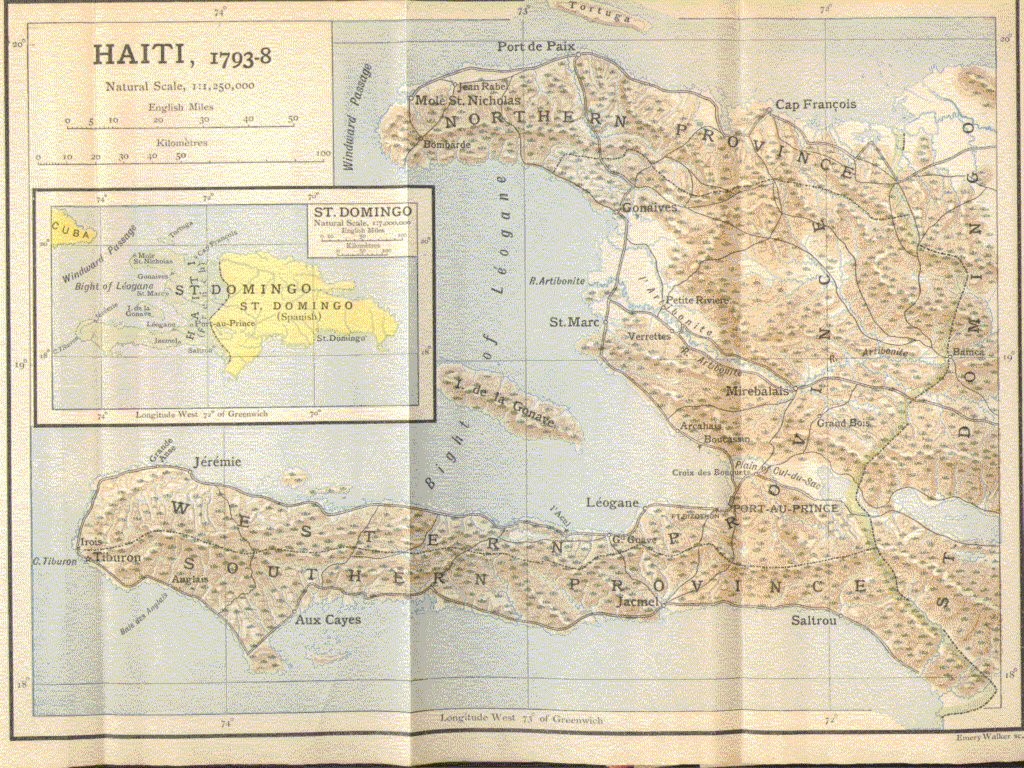
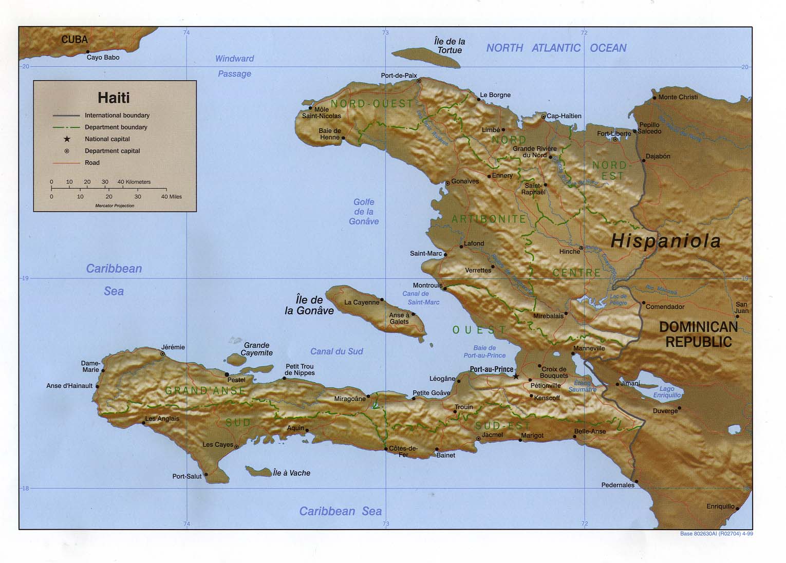
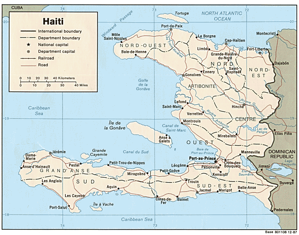
If anyone finds a good map for the Bainet area with streams, etc., please contact me. RJR |
DESCRIPTION de la Paroisse de BAINET faite par MOREAU de SAINT-MERY dans son livre DESCRIPTION de la Partie Française de l'Isle de St. Domingue publié la première fois en 1789
Paroisse de BAINET: Une baie de 1650 toises d'ouverture et de 930 toises de profondeur sans aucun ressif[?], a inspiré le nom que porte cette paroisse et que l'usage veut qu'on écrire BAINET au lieu de "BAIE.NETTE", ou au moins BAINETTE. Les premiers établissements de BAINET ne remontent qu'au temps de la Compagnie de St. Domingue. En 1718, on en fut une paroisse sous l'invocation de St. Pierre, mais les habitants s'occupaient si peu de construire une église et un presbytère, qu'un arrêt du Conseil de PETIT-GOAVE du 8 mars 1725, le leur prescrivit, les registres de cette paroisse vont cependant jusqu'au 28 avril 1718.
La paroisse de BAINET, trés ètendue, est bordée au Sud par la mer, depuis l'embouchure de la anse à Canot jusqu'a celle de la rivière des côtes de fer, à l'Est, par la paroisse de JACMEL, au Nord, par les chaînes de montagnes du GRAND et du PETIT GOAVE, au NORT-OUEST par le canton des GODETS de la paroisse du FOND DES NEGRES, au moyen de la Rivière du FOND DES NEGRES, enfin à l'OUEST, d'abord par la paroisse du FOND DES NEGRES et ensuite par la paroisse d'ACQUIN toujours au moyen de la même rivière qui devient celle de la COTE DE FER jusqu'a son embouchure.
Le sol de cette paroisse est prodigieusement montreux et entrecoupé par des ravines profondes et encaissées, les caisses des montagnes se prolongent quelquefois jusqu'à la mer.
Sur la côte, on trouve 2300 toises de l'embouchure de la Rivière à CANOT à la rivière de la Brésiliènne, qui manque d'eau à son embouchure, pendant 9 mois de l'année. De là à la Rivière du TROU-MAHOT est un petit îlet de roches nommé le COLOMBIER et de cet îlet à la rivière de l'AZUR, qui est plutôt une forte source, 1525 toises.
Un quart de lieue de la rivière de l'Azur à la pointe est de la baie de BAINET, environ 500 toises de cette pointe à la petite anse et encore 500 toises jusqu'a la rivière du bout de l'Anse à Canot jusqu'au bourg de BAINET, 7450 toises. La côte est de fer (très difficile) de l'Anse à CANOT à la rivière de l'Azur, les caboteurs trouvent cependant refuge à l'Anse à CANOT et au TROU-MAHOT.
Le Bourg de BAÎNET, situé vers l'angle NORD-EST de la baie est composé de trois maisons couvertes, don’t une sert de chapelle et de presbytère depuis que l'ouragan du 5 Septembre 1781 a renversé l'église, et de 20 cases couvertes de pailles semée au hazard. L'ouragon du 21 Septembre 1751 n'avait laissé, au contraire, que l'église et le presbytère.
Il y a dans ce bourg, un exempt, un brigadier et quatre archers de la maréchaussée établis par l'Ordonnance du 8 fèvrier 1775.
De la rivière du BOUT de l'Anse à la GRANDE-RIVIÈRE, qui a 10 toises de largeur, au point ou le grand chemin qui va à ACQUIN, la traverse, il y a 735 toises et une forte lieue de l'embouchure de cette Grande Rivière au CAP BAINET qui termine la Baie à l'OUEST.
Le mouillage est assez bon à BAINET, il est entre la rivière du BOUT de l'Anse à la GRANDE-RIVIÈRE et environ a deux encablures de la terre avec 25,30, et 40 pieds de profondeur et de bonne tenue, mais le vent d'Est auquel la baie est ouverte, y souffle avec force pendant 9 mois de l'année et la mer y est agitèe. On y souffre aussi des coups de vent du sud et des raz-de-marèe.
A une lieue et demie (1.5) du Cap BAÎNET est encore une "Petite Anse" et à trois quart (3/4) de lieue de celle-ci le CAP RAIMOND qui devance les sources à BERGASSE et qui est lui même à une lieue et demie de l'ANSE de GUIGNE à GAUCHE. Dans l'intervalle est l'embouchure de la rivière de CORAIL et celle de la Petite Rivière des côtes de Fer qui termine le canton de GRIS-GRIS et qui se trouve à 7640 toises d'ouverture sur environ 300 toises de profondeur. Enfin, à 9710 toises de la Petite Rivière de Fer, distance où se trouve encore l'anse de la Brésilienne, l'anse des GRIS-GRIS et la pointe des côtes de Fer, se trouve l'embouchure de la rivière des Côtes de Fer, limites de la paroisse de BAINET et de celle d'ACQUIN.
La côte de la paroisse de BAINET a donc 24800 toises d'étendue, elle est preque toujours bordée de rochers que la mer bat avec une violence extrèment n'offre qu'une douzaine d'embarcadères.
BAINET, eprouve quelquefois de trés grandes secherenes, on y cultive l'indigo et du coton dans les parties voisines de la mer, le café dans les parties montagneuses elevèes et du tabac extrèmeement renomé le long des rivières. Il y avait par example, dès 1730, 57 indigateries et 67 en 1740.
BAINET a une situation relativement isolée, par rapport aux autres points de la colonie. La ville de BAINET depend du commendement de la sénéchaussée et de l'Amiranté de JACMEL.
Il y a 4 voies de communication qui partent de BAINET, l'une va vers l'Est chercher la ville de JACMEL eloignée de 7 lieues, la seconde va vers ACQUIN le long de la côte et a environ 19 lieues de long, la troisième monte et traverse les montagnes du Nord pour rerendre au GRAND-GOAVE eloigné de 10 lieues. La quatrième communication va au PETIT-GOAVE, par courant jusqu'a 13116 toises. Aucun de ces chemins n'est pratiquable en voiture.
La population de BAINET était en 1730 de 317 blancs, 12 affranchis et 700 esclaves, en 1789 de 388 blancs, 800 affranchis et 5500 esclaves.
La milìce comportait en 1730 63 blancs et 1 affranchi et en 1789 90 blancs et 240 affranchis.
Cette paroisse présente le disavantage d'être obliyée d'envoyer ses deurées à JACMEL à dos de mulets, parce qu'il est difficile de remonter jusque là par la mer et que la nature des chemins ne laisse pas le choix des moyens de transport.
Tableau des mesures employées à St. Domingue
1 carreau = 1 ha 13 a 7 ca
1 arpent = 34 a 18 ca ~ 1 acre
1 lieue = 2000 toises = 3km89
1 toise = 1m949 ~ 1 fathom (6 pieds)
1 pied = 12 pouces = 144 lignes = 0,3248 m ~ 1 foot
1 pouce = 0,027 m
1 ligne = 0,225 cm
1 aune = 1,188 cm
1 livre de Paris = 0,489 kg ~ 1 pound
En 1789: il y avait à St. Domingue 40000 blancs, 28000 affranchis et 452000 esclaves soit environ 500000 habitants.
Il existait à St. Domingue un monnaie coloniale appelée Piastre-Gourde qui valait huit livres cinq sous.
L'argent de France - monnaie courante en France = Livre Tournois, valait 50% de plus que la monnaie coloniale de St. Domingue.
100 livres argent de France = 150 livres coloniales ou Piastre Gourde si on trouve des actes, sans aucun désignation particulière, c'est toujours l'argent des colonies qu'il faut entendre.
DESCRIPTION of the Parish of BAINET made by MOREAU de SAINT-MERY in his book DESCRIPTION of the French Part of the Isle of St Domingue published the first time in 1789
Parish of BAINET: A bay of 1,650 fathoms [a fathom equals six feet] width and 930 fathoms of depth without constriction[? ], inspired the name which this parish carries and the use where one wants to write BAINET instead of "BAIE NETTE", or at least BAINETTE. The first establishment of BAINET goes back to the time of the Company of St Domingue. In 1718, there was a parish under the invocation of St Pierre [dedicated to St. Peter?], but the inhabitants occupied themselves but little to build a church and a presbytery, so that a stop order [for establishment of a separate parish?] was prescribed by the Council of PETIT-GOAVE on March 8, 1725. The registers of this parish go however until April 28, 1718.
The parish of BAINET, being very wide, is bordered in the South by the sea, from the mouth of Canoe Creek until that of the river of the Côtes de Fer (Iron Coasts); in the East,by the parish of JACMEL, in North, by the assembly lines of GRAND and SMALL GOAVE [guava?], in the Northwest by the Canton of the GODETS (Cups) of the parish of Negroes Seat [?], by means of the Negroes Seat River, finally in the West, initially by the parish of ACQUIN always by means of the same river which becomes that of the Iron Coasts, and on until its mouth.
The ground of this parish is prodigiously hilly and intersected by deep and boxed gullies, the cases of the mountains are prolonged sometimes to the sea.
On the coast, one finds [it is] 2,300 fathoms from the mouth of Canoe River to the Brésiliènne River, which lacks water at its mouth for nine months of the year. From there to the TROU-MAHOT River is a small islet of rocks named the DOVECOTE and from this islet to the River of Azure, which is rather a strong source, [it is a distance of] 1,525 fathoms.
[It is] a quarter of a league from the Azure River to the eastern point of the bay of BAINET; approximately 500 fathoms from this point to the Petite Anse (little bay, creek, cove); and still another 500 fathoms until the river. From the end of Canoe Cove to the borough of BAINET [it is] 7,450 fathoms.
The East Coast is "of iron" (very difficult) from Canoe Cove (L'Anse à Canôt) to the River of Azure; however, the coast dwellers find refuge within Canoe Cove and the TROU-MAHOT [a coastal cave?]. The Borough of BAÎNET, located towards the North-eastern angle of the bay is composed of three covered houses [buildings], giving the setting the [?] the chapel and presbytery after the hurricane of September 5, 1781 overthrew the church, and strewing here and there the 20 straw covered cases [thatched dwellings?]. By contrast, the hurricane of September 21, 1751 had not left anything other than the church and the presbytery.
There is in this borough, an exempt [tax exempt?, meaning unsure], a brigadier and four archers in the Marechalship (constabulary) established by the Ordinance of 8 February 1775.
From the River at the extreme end of the little bay of Grand-River, which is 10 fathoms in width, to the point where the main road which goes to ACQUIN crosses it, it is 735 fathoms and a good strong mile from the mouth of this Grand River to the CAPE BAINET which finishes [at the]Bay in the west.
Natural moisture is rather good at BAINET, it is [situated] between the river of the end of the little bay of Grand-River and has approximately two encablures [an "encablure' or cable length is approximately 200 yards]of soil 25, 30, and 40 feet in depth and good behaviour [quality]; but the East wind, to which the bay is opened, blows there with force for nine months of the year and the sea is agitated there. One also suffers there from the strong gales of the south and from the strong sea current.
Within one and a half miles from Cape BAÎNET is another " Small Cove " and three quarters of a mile from this one [lies] Cape Raimond which comes before the sources at Bergasse and from which is similarly another mile and a half from the Little Bay of Guigne (Sweet Cherry Cove) to the left. In the interval [i.e., between these] is the mouth of the Coral River and that of the Small River of the Iron Coasts which finish the Canton of GRIS-GRIS and which is 7,640 fathoms [wide at the] opening and approximately 300 fathoms in depth.
Finally, 9,710 fathoms from the Little River of Iron, over a distance where one finds still the little bay of the Brazilian [River], the bay of the GRIS-GRIS and the Point of the Iron Coasts, is the mouth of the River of the Iron Coasts, the boundary limit of the parish of BAINET and that of ACQUIN. The coast of the parish of BAINET is thus 24,800 fathoms in extent; it is nearly always bordered by rocks which the sea beats with an extreme violence and only offers one dozen landing places.
BAINET, has occasionally tested very large drying warehouses. One cultivates there both indigo and cotton in the parts close to the sea, coffee in the mountainous elevated parts, and widely reknowned tobacco along the rivers. There were, for example, in 1730, 57 indigatories [indigo plantations/factories] and 67 in 1740.
BAINET has a relatively isolated situation, compared to the other points of the colony. The town of BAINET falls under the jurisdiction of the Seneschalship and Admiralty of JACMEL.
There are four transportation/communication channels which start from BAINET: one towards the East will seek the town of JACMEL seven miles distant, the second goes towards ACQUIN along the coast and is approximately 19 miles in distance, and the third assembles and crosses the mountains of the North for connecting with GRAND-GOAVE ten miles distant. The fourth communication goes to PETIT-GOAVE, traversing some 13,116 fathoms. None of these paths is praticable in the car. [Translator's note: this voiture or "car" would mean a horse or muledrawn carriage and not a modern automobile, obviously].
The population of BAINET was in 1730 [comprised] of 317 whites, 12 freedmen, and 700 slaves; in 1789 [there were] 388 whites, 800 freedmen, and 5,500 slaves. The militia was comprised in 1730 of 63 white and 1 freedman; and in 1789 of 90 whites and 240 freedmen.
This parish presents the disadvantage to be obligated to send its "deurées" [goods, products?] to JACMEL by muleback, because it is difficult to go up there by sea and that the nature of the paths does not leave that choice as a means of transport.
Table of measurements employed at St. Domingue
1 carreau (square) = 1 hectare (ha), 13 ares (a), 7 centiares (ca)
1 arpent = 34 a, 18 ca, or approximately 1 acre
1 lieue (league) = 2000 toise = 3.89kilometers (km)
1 toise (fathom) = 1.949 meters (m), or approximately 1 fathom (6 feet)
1 pied (foot) = 12 pouces = 144 lignes = 0,3248m, or approximately 1 foot
1 pouce (inch) = 0,027 m
1 ligne (line) = 0,225 cm
1 ell = 1,188 cm
1 livre (pound) de Paris = 0,489 kg or approximately 1 pound
In 1789 there were in St. Domingue: 40,000 whites, 28,000 freedmen and 452,000 slaves for a combined total of approximately 500,000 inhabitants.
There existed in St. Domingue a colonial currency called "Piastre-Gourde" which was worth eight pounds five pennies.
Money of France - current currency in France = Tours Pound, was worth 50% more than the colonial currency of St Domingue.
100 pounds money of France = 150 pounds colonial or Gourde Piastre. If contracts are found, without any particular designation, it is always the money of the colonies which is understood [took precedence].
Author's note: Not being the subject matter expert, I have not attempted an exact translation of several things that I not know since I am not from Haiti, in fact not a local of the specific area. For example, "l'anse" can mean handle as in the handle of a frying pan or meat cleaver. Grande Anse describes that portion of southwestern Haiti which looks like a handle; however, "l'anse" might also mean "bay, creek, or cove"and could mean a small inlet. Some things shouldn't really be translated but left to their original French names. I always welcome corrections or new information and I shall be glad to correct my text when there is a better translation. Another example:
"piastre gourde". Piastre surely means "dollar"; however, in Cassell's English/French dictionary, one finds:
Gourde: n.f. Gourd, calabash, wicker bottle, flask, wineskin; (pop) idiot, fathead.
Personnally I like the idea of a wineskin full of nice wine being the equivalent in trade of a "dollar"; however, I will leave it to the reader to research this matter until I am better informed. RJR